Paul Abraham Whittock
The University of Edinburgh, Edinburgh, Scotland
Introduction
Increasing greenhouse gas concentrations are expected to have significant impacts on the world's climate (Fig. 1) on a timescale of decades to centuries. Evidence from long-term monitoring studies suggests that the climate of the last few decades is anomalous compared with past climate variation, and that recent climatic and atmospheric trends are already affecting species’ physiology, distribution and phenology (Hughes, 2000). Among the species likely to be threatened by these climatic and atmospheric trends are sea turtles.
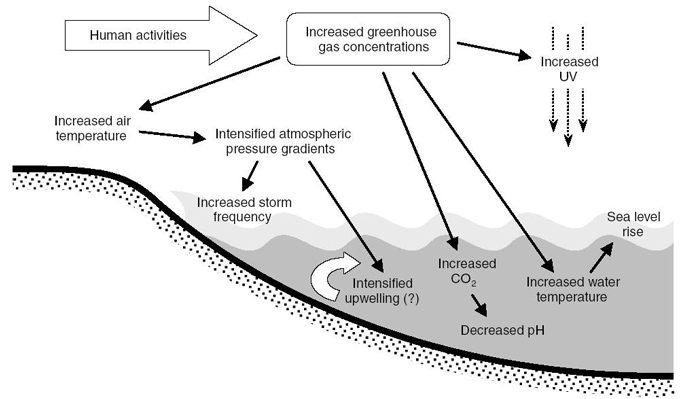
Fig. 1. The predicted impacts of human-induced climate change (Christopher et al., 2006).
Sea turtles utilise a variety of habitats at different stages of their lives, and each of these habitats, and the turtle’s behaviour within them, may be affected by climate change in an adverse way (Hawkes et al., 2007; Pike, Antworth & Stiner, 2006; Saba et al., 2007; Saba et al., 2008; Van Houton & Bass, 2007). For example, an increase in sea level reduces the suitable area available for nesting (Fish et al., 2005), and increasing temperatures can affect growth, sex ratios and distribution (Glen et al., 2004). Sea level changes could be magnified further from erosion caused by increased precipitation intensity and storm frequencies. This is of concern in Greece, as the largest aggregation of loggerhead sea turtle nests in the Mediterranean is found on the beaches of the Greek island of Zakynthos (Margaritoulis et al., 2003).
Aim
The main aim of this project is to identify whether future predicted sea level rise, within the Mediterranean Sea, will impact on the Zakynthos loggerhead sea turtle nesting habitat in a negative way, potentially resulting in a reduced population.
Objectives
- Model sea level rise (SLR) scenarios (as determined by the latest IPCC global sea level rise predictions) against elevation data of Laganas Bay, Zakynthos, to determine the percentage of beach area lost.
- Carry out morning/night surveys to identify the loggerhead nesting area and nesting elevation range.
- Carry out a land use survey along the back of each beach to identify the adaptation potential for natural beach regression following SLR.
- Identify the percentage of the nesting area which lies within the beach area under threat, as determined by the SLR scenarios. The identification of areas under threat will enable management techniques to be effectively targeted for each beach.
- In order to identify the potential for the loggerhead sea turtle population to adapt to sea level rise, the nesting area on each beach will be recalculated for shifts in nesting area elevation related to the SLR scenarios.
Site description
The island of Zakynthos is located in the Ionian Sea in the Mediterranean (37°38’ to 37°56’ N and from 20°37’ to 21°00’E). Laganas Bay, on the south-east side of Zakynthos, is host to the most important and largest loggerhead sea turtle nesting beaches within the Mediterranean (Margaritoulis et al., 2003).
Laganas bay is 20km in length and is almost semi-circular in shape, with its 12km wide mouth facing SSE. The nesting area consists of six discrete nesting beaches, totalling 5.5km in length, which hold 857-2018 nests per year (Margaritoulis, 2005). The six distinct beaches are called Marathonissi, East Laganas, Kalamaki, Sekania, Daphni and Gerakas. Five of the beaches occur at irregular intervals along the coastline of the bay, and each is separated by rugged promontories. The sixth beach is on Marathonissi, an islet found within the bay. Each nesting beach is different in many aspects such as length, orientation, wave action, beach profile, vegetation cover, land use behind the beach, sand colour and content, and human disturbance.
Methods
Identifying the beach area under threat
Four scenarios of potential future SLR were used in the analysis. Three scenarios (0.2m, 0.4m and 0.6m) represented SLR predictions for 2090-2099, made in the 4th IPCC report (IPCC, 2007a). The fourth SLR scenario (1m) represented conditions following a storm surge or a large storm event. For many locations, SLR may have a greater impact by modifying storm damage rather than directly causing inundation or erosion. Increases in sea level may produce greater wave attack and flooding, thus amplifying the impact of erosion from a particular storm. Viewed in another way, a one metre rise in sea level might enable a 15 year storm event to flood and erode many areas that today are only affected by a 100 year storm event.
- Modelling the sea level rise scenarios
The four sea level rise scenarios were modelled against a Digital Elevation Model (DEM) of Laganas Bay (not including Marathonissi Island) using IDRISI 32. This enabled the identification of the beach area under threat from a specific rise in sea level by highlighting the area of the beach that will be inundated in the future. It was not possible to model the evolution of the beach morphology due to the lack of available resources, data and time. Therefore, the identification of the nesting habitat under threat from SLR was based entirely on the beach elevations and characteristics identified from the DEM.
- Measurements of beach characteristics
The characteristics of five of the six nesting beaches (excluding Marathonissi), including width, length, aspect, elevation and slope angle, were identified using a GPS receiver (Model: Garmin etrex Vista CX) and the DEM of Laganas Bay.
- Identifying vulnerability to sea level rise
The vulnerability is a measure of the physical impact caused by a specific hazard. In this project the physical impact is measured by the proportion of each nesting beach lost following the hazard of a 0.4m rise in sea level.
Identifying the nesting habitat under threat
- Identifying the nesting area
Between the 27th May and 23rd July 2007 the coordinates of each loggerhead nest laid on each nesting beach were recorded using the GPS receiver. The purpose of collecting the nest coordinates was to identify the extent of the nesting area used by the loggerhead sea turtle on each nesting beach. The front extent of the nesting area was determined by the 0.3m beach elevation contour, which is commonly regarded to be the elevation at which it becomes suitable for loggerheads to nest (Maktav et al., 2000).
- Identifying the nesting area under threat
ArcView 9.1 and IDRISI 32 were used to identify the impact of each SLR scenario on the nesting habitat area. The area of beach which lies within the inundated nesting habitat area was calculated to find the area affected. This area was then compared with the overall nesting habitat area on the beach in order to find the proportion of nesting habitat under threat. This was repeated for each SLR scenario on each individual nesting beach.
Adaptation to sea level rise
The proportion of the nesting habitat area which lies within the beach area under threat (identified in the section above) was calculated while assuming there was no change in the beach morphology. However, a beach’s morphology is dynamic, and will adapt and change naturally in response to changes in sea level. The beach will retreat inland with a rise in sea level resulting in a similar beach profile (Pilkey & Cooper, 2004), potentially remaining suitable as a sea turtle nesting habitat. Therefore, in order to identify the realistic percentage of nesting habitat under threat, it was necessary to identify the potential for the beach to adapt to the rise in sea level. The main factor affecting this landward beach movement, in response to SLR, is the presence of urban developments at the back of the beach. Buildings, roads, coastal defence schemes and other constructions all contribute to ‘coastal squeeze’, i.e. when landward movement of beaches is prevented by coastal development (Gill et al., 2004). Therefore, a survey of the land use along the back of each nesting beach was carried out in order to identify the areas where landward beach regression was restricted. The boundaries of each land use were identified directly using the GPS receiver and indirectly through georeferencing aerial photographs in ArcView 9.1. Each nesting beach was split into 20m sections and the land use was identified for each section. The categories of land use were development (includes hotels, walls, roads and other buildings), scrub, dunes and cliff areas.
- Identifying the potential for adaptation to sea level rise
Female loggerheads also have the potential to adapt in cases where landward beach movement, in response to SLR, is constrained. Inundation of currently preferred nesting areas could result in loggerheads shifting their nesting sites further up the beach (Fish et al., 2005). For example, following a SLR of 0.2m, sea turtles will respond by shifting their nesting elevation range by 0.2m, again assuming no change in beach morphology. However, due to constraints and obstacles associated with developments at the back of the beach (identified from the land use survey – see previous paragraph), this response to SLR may be prevented resulting in a reduced nesting habitat. In order to identify this, the nesting elevation range of the loggerhead was calculated by superimposing the nesting habitat area on the DEM in ArcView 9.1.
Combining the results of the land use survey with the DEM and the loggerheads’ nesting elevation range made it possible to calculate the beach area that lies within the potential shifted nesting elevation range following a rise in sea level. This analysis was only carried out in areas where land use restricts the landward retreat of the beach. In the absence of data that would account for possible changes in beach morphology, this shift in nest distribution provided some indication of the potential for adaptation (Fish et al., 2005).
Results
Beach area under threat
The surveyed beaches represented an overall area of 179234m². The largest beach was East Laganas beach with an overall area of 119462m², 66.7% of the overall nesting beach area. The smallest beach was West Sekania with an overall area of 5521m², 3.2% of the overall nesting area. Under the most conservative rise in sea level (0.2m), 12.6% of the total current beach area would be inundated. This increased to 26.6%, 38.2% and 54.3% under a 0.4m, 0.6m and 1m rise in sea level, respectively (Fig. 2). The most vulnerable beach, taking vulnerability as the proportion of the beach that would be inundated under the scenario of a 0.4m rise in sea level, was East Laganas beach of which 30.1% could be lost. The largest proportion of beach inundated was Gerakas beach of which 60.1% could be inundated under a sea level rise of 1m.
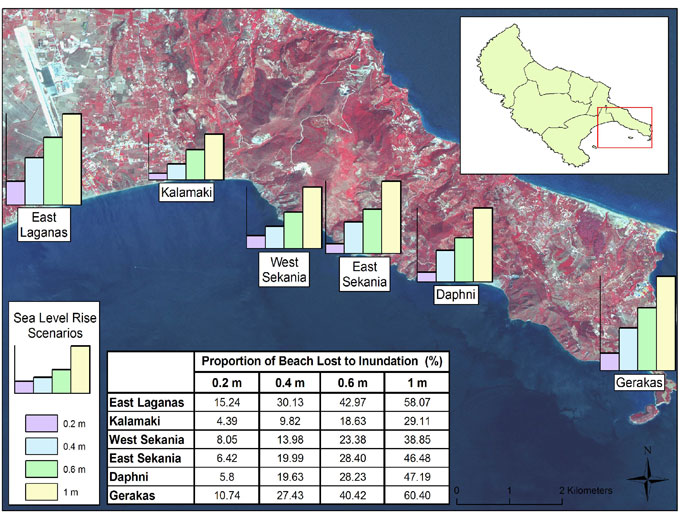
Fig. 2. Proportion of beach lost to inundation under various sea level rise scenarios.
Land use survey
The main land use type found at the back of each beach was dune with 50% of the entire beach area containing dune. The highest proportion of dune found on any individual beach was at East Laganas beach where 75% of the beach was backed entirely by dune. Development was found along the back of 21% of the overall beach. The highest proportion of development found on any individual beach was at Daphni beach where 81% of the beach was backed entirely by development. Only 3% of the back of all the beaches contained scrub with 85% of the overall scrub being found on West Sekania beach. Clay cliffs backed up to 25% of the overall beach with 50% of all cliff being found along the back of Gerakas beach.
Current nesting habitat under threat
It was found that under a sea level rise of 0.2m none of the nesting area would be inundated. This increased to 11% (±56% SD), 29% (±38% SD) and 51% (±29% SD) under a sea level rise of 0.4, 0.6 and 1m respectively. Different beaches had varied beach profile characteristics (with respect to width, slope angle and elevation) and therefore each beach differed in the extent to which the nesting area within it was threatened (Fig. 3). The largest proportion of an individual beach’s nesting area to be inundated was at Daphni beach where, under a sea level rise of 1m, 58% of the nesting area would be lost. East Laganas beach had the highest proportion of nesting area lost after a sea level rise of 0.6m, with 34% of the overall nesting area being inundated. Out of all the nesting beaches, Kalamaki beach had the lowest proportion of nesting area lost for each SLR scenario, with 3%, 15% and 30% of the nesting area lost after sea level rises of 0.4, 0.6 and 1m respectively.
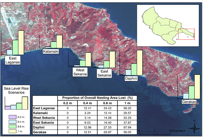
Fig. 3. Proportion of nesting habitat lost to inundation under various SLR scenarios.
Restricted shift in nesting range
It is assumed that turtles, in areas where landward beach migration in response to SLR is constrained, will adapt to SLR by simply shifting their nesting range further up the beach to avoid further inundation of the preferred nesting area. To model this shift the nesting area was recalculated for elevation shifts of 0.2, 0.4, 0.6 and 1m. The nesting area no longer in the beach area, following the shift, was recalculated to identify the area of beach lost. This recalculation was completed twice, the first recalculation assuming that the landward beach movement in response to sea level rise was completely constrained and that the land use at the back of the beach would not be able to accommodate a shift in nesting range, i.e. not suitable for nesting. The second recalculation assumed that certain types of land use would be able to accommodate a shift in nesting range, i.e. some areas at the back of the beach would be suitable for nesting.
| | Nesting Area Remaining Following Adaptation (m²)
(Proportion of Nesting Area Remaining %) |
|---|
| Beach | Original | 0.2m | 0.4m | 0.6m | 1m |
|---|
| East Laganas | 63761 | 58566 (91.9) | 48320 (75.8) | 41452 (65) | 31606 (49.6) |
| Kalamaki | 10205 | 10079 (98.8) | 9422 (92.3) | 8901 (87.2) | 7688 (75.3) |
| West Sekania | 4301 | 4063 (94.5) | 3729 (86.7) | 3360 (78.1) | 2747 (63.9) |
| East Sekania | 8021 | 7958 (99.2) | 7715 (96.2) | 7139 (89) | 5781 (72.1) |
| Daphni | 7996 | 7295 (91.2) | 6186 (77.4) | 4957 (62) | 2948 (36.9) |
| Gerakas | 7190 | 6648 (92.5) | 6004 (83.5) | 5465 (76) | 3766 (52.4) |
| Average | 16912 (100) | 15768 (93.2) | 13563 (80.2) | 11879 (70.2) | 9059.8 (53.6) |
| Total | 101474 (100) | 94609 (93.2) | 81376 (80.2) | 71275 (70.3) | 54359 (53.6) |
Table 1. The individual nesting area remaining on each beach following a restricted shift in response to four scenarios of sea level rise: 0.2, 0.4, 0.6 and 1m.
The potential for beaches to accommodate shifts in nest distribution varies significantly with land use behind the beach. Within Laganas Bay, each land type (cliff, scrub, development and dune) is different in its ability to accommodate shifts in nest distribution. It was assumed that beaches with either cliff or development at the back of the beach would not be able to accommodate any shifts in nest distribution. It is assumed that the clay cliffs at the back of the beach will generally retreat inland, but the resulting beach conditions as a result of the erosion are likely not to be suitable as a nesting area for loggerheads. The main reason for this conclusion is the short time scale in which the beach erosion will take place. It is assumed that beaches with either a dune system or scrub at the back of the beach would be able to accommodate shifts in nest distribution. The only beaches to be affected by these new assumptions are East Laganas and Gerakas, as the land use at the back of each beach is a combination of dune, development and cliff. Beaches with a land use that completely restricts landward beach migration includes Kalamaki beach and Daphni beach. Beaches with a completely unrestricted land use include both West and East Sekania beach.
| | Nesting Area Remaining Following Adaptation (m²)
(Proportionof Nesting Area Remaining %) |
|---|
| Beach | Original | 0.2m | 0.4m | 0.6m | 1m |
|---|
| East Laganas | 63761 | 62322 (97.7) | 61939 (97.1) | 61143 (95.9) | 57742 (90.6) |
| Kalamaki | 10205 | 10079 (98.8) | 9422 (92.3) | 8901 (87.2) | 7688 (75.3) |
| West Sekania | 4301 | 4301 (100) | 4301 (100) | 4301 (100) | 4301 (100) |
| East Sekania | 8021 | 8021 (100) | 8021 (100) | 8021 (100) | 8021 (100) |
| Daphni | 7996 | 7295 (91.2) | 6186 (77.4) | 4957 (62) | 2948 (36.9) |
| Gerakas | 7190 | 6933 (96.4) | 6445 (89.6) | 6138 (85.4) | 4822 (67.1) |
| Average | 16912 | 16492 (97.5) | 16052 (94.9) | 15577 (92.1) | 14254 (84.3) |
| Total | 101474 | 98951 (97.5) | 96314 (94.9) | 93461 (92.1) | 85522 (84.3) |
Table 2. The individual nesting area remaining on each beach following a partially restricted shift in response to four scenarios of sea level rise: 0.2, 0.4, 0.6 and 1m.
Discussion
As expected, the physical characteristics of each beach determined its vulnerability to increases in sea level. Beaches with low elevations and low slope profiles were found to lose large proportions of their beach area. The average proportion of beach lost, under a 0.4m rise in sea level, is predicted to be 27%, with this rising to 54% under a SLR of 1m. The total nesting area was identified to be 101474m² of which 11% would be lost under a SLR of 0.4m, increasing to 51%under a SLR of 1m.
Management of the nesting beaches
The dune system behind West Laganas beach should allow a response and adaptation of the beach to SLR. However, this assumes that the dune system remains healthy and currently there are a number of activities that compromise this, including the use of beach furniture in the dune system. Efforts should be made to ensure that the existing dune system remains healthy and all activities compromising this (e.g. use of vehicles) are prevented.
The land use behind the beach will allow little adaptation of the beach to SLR. After episodic periods of high waves and storms, areas of beach which are unable to retreat naturally will experience high beach profiles caused by 'coastal squeeze'. The constrained steep beach profile at Kalamaki may already provide evidence of on-going coastal squeeze.
Sekania beach, which is commonly regarded to be the single most important nesting beach in the Mediterranean for the loggerhead sea turtle, is in an ideal natural state. The land use combination of scrub and dune should allow the beach to retreat and adapt naturally in response to SLR. A restricted nesting habitat caused by a reduced suitable nesting habitat area on Sekania and on the surrounding nesting beaches could lead to an increase in the incidence of loggerheads digging up existing incubating nests in order to lay their own nest.
The need to remove the developments (which has been a legal obligation of the Greek government since 1987) is based not only on the fact the developments are illegal, but also on their severe impact upon the beach and nesting turtles. This need is further magnified by the demonstrated developments’ impact on the potential for adaptation to SLR by the nesting turtle and Daphni beach itself.
Gerakas is a popular beach for tourists. Currently, the National Marine Park of Zakynthos (NMPZ) and Archelon operate patrols on the beach to ensure visitors do not interfere with incubating nests on the beach (most of which are unmarked) and operate guidelines to ensure visitors stay within 5m of the shoreline. With a predicted reduction in beach area and nesting habitat the space available for both visitors and nesting females will be reduced, increasing the competition for space and potentially increasing the chances of disturbances to incubating nests.
Management options
There are four recognised categories in mitigating the factors which threaten the nesting beach habitat from SLR, these being:
- Eliminate the threat
- Risk reduction/managed risk
- Translocation of eggs
- ‘Do nothing’ alternative
Although the natural events that cause erosion and accretion cannot be prevented, their consequences can often be reduced. In Zakynthos, the loggerhead nesting beaches are located in an ideal area for tourism development and many temporary and permanent residences exist close to some of the beaches, particularly along the back of East Laganas, Kalamaki and Daphni beaches. One of the most important indirect effects of development is the necessity to protect the coastal property from erosion. In protecting property coastal armouring is often used. One management option used to limit the need for future coastal armouring in response to SLR is for the establishment of setback requirements for any further developments close to the beach.
Risk reduction/managed risk is therefore the favoured option as it involves using management techniques such as dune restoration and set back zones to enable the beach to prepare for, avoid, moderate and recover naturally from future SLR (Dolan & Walker, 2003).
Conclusion
- Up to 54% of the overall surveyed beach area will be lost to inundation following a SLR of 1m.
- The average proportion of the Zakynthos nesting area lost under a SLR of 0.4m was 11%, with this figure rising to 51% under a SLR of 1m.
- The direct impact of SLR on the nesting habitat could therefore severely impact on both the nesting behaviour and nesting success of the Zakynthos loggerhead population.
- The National Marine Park ofZakynthos should ensure that each beach remains in a conditionsuitable for a natural retreat following SLR. This involvesmaintaining existing dune systems, reinstating dune systems andensuring no new developments are allowed within a certain distancefrom the shoreline.
- Measures for mitigating impactsassociated with climate change should focus on increasing theresiliency of both the loggerhead population and nesting beach.Increasing the resiliency will increase the capacity for theloggerhead and nesting beach to prepare for, avoid, adapt to and recover from the effects of climate change.
Aspects of the sea turtle life cycle hinder turtles’ ability to respond effectively to climate change. Sea turtles are characterized by slow maturation time, temperature-dependent sex determination, and a near-total reliance on existing nesting beaches (philopatry). When combined with decreases in quality and quantity of foraging areas, plus the potential for reductions in nesting areas revealed by this paper, these characteristics are likely to contribute to a decrease in future loggerhead populations in the Mediterranean region. There is no evidence from the past that sea turtles have ever experienced such a rapid and extreme shift in climate conditions. The likelihood of loggerhead sea turtles being able to adapt and evolve to survive projected climate changes over the next century seems low indeed.
Acknowledgements
With thanks to: WWF Climate Change Programme, WWF Italy, WWF Greece, WWF Global Species Programme, the University of Edinburgh, ARCHELON – The Sea Turtle Protection Society of Greece, the National Marine Park of Zakynthos and the British Chelonia Group.
References
Christopher, D.G., Harley, A., Hughes, R., Hultgren, K.M., Miner, B.G., Sorte, C.J.B., Thornber, C.S., Rodriguez, L.F., Tomanek, L. & Williams, S.L. (2006). The impacts of climate change in coastal marine systems. Ecology Letters 9: 228-241.
Dolan, I.H. & Walker, J.H. (2003). Understanding vulnerability of coastal communities to climate change related risks. Journal of Coastal Research, Special Issue 39.
Fish, M.R., Cote, I.M., Gill, J.A, Jones, A.P., Renshoff, S. & Watkinson, A.R. (2005). Predicting the impact of sea-level rise on Caribbean sea turtle nesting habitat. Conservation Biology 19: 482-491.
Gill, J., Watkinson, A. & Cote, I. (2004). Linking sea level rise, coastal biodiversity and economic activity in Caribbean island states: towards the development of a coastal island simulator. Tyndall Centre Technical Report 9. Available at: www.tyndall.ac.uk/research/theme4/final_reports/it1_38.pdf. <Accessed on: 5/4/07>
Glen, F. & Mrosovsky, N. (2004). Antigua revisited: the impact of climate change on sand and nest temperatures at a hawksbill turtle (Eretmochelys imbricata) nesting beach. Global Change Biology 10: 2036-2045.
Hawkes, L.A., Broderick, A.C., Godfrey, M.H. & Godley, B.J. (2007). Investigating the potential impacts of climate change on a marine turtle population. Global Change Biology 13: 1-10.
Hughes, L. (2000). Biological consequences of global warming: is the signal already apparent? Trends in Ecology & Evolution 15 (2): 56-61.
IPCC. (2007a). Climate Change 2007: the physical science basis – summary for policymakers. Available at: www.ipcc-wg2.org
IPCC. (2007b). Climate Change 2007: impacts, adaptation and vulnerability. Available at: www.ipcc-wg2.org
Maktav, D., Sunar, F., Yalin, D. & Aslan, E. (2000). Monitoring loggerhead sea turtle (Caretta caretta) nests in Turkey using GIS. Coastal Management 28: 123-132.
Margaritoulis, D., Argano, R., Baran, I., Bentivegna, F., Bradai, M.N., Camiñas, J.A., Casale, P., Metrio, G.D., Demetropoulos, A., Gerosa, G., Godley, B.J., Haddoud, D.A., Houghton, J., Laurent, L. & Lazar, B. (2003). Loggerhead turtles in the Mediterranean Sea: present knowledge and conservation perspectives. In: Bolten, A. B., Witherington, B.E. (Eds.), Loggerhead Sea Turtles. Washington, pp. 175-198.
Margaritoulis, D. (2005). Nesting Activity and Reproductive Output of Loggerhead Sea Turtles, Caretta caretta, Over 19 Seasons (1984-2002) at Laganas Bay, Zakynthos, Greece: The Largest Rookery in the Mediterranean. Chelonian Conservation and Biology 4: 916-929.
Pike, D.A., Antworth, R.L. & Stiner, J.C. (2006). Earlier nesting contributes to shorter nesting seasons for the Loggerhead Seaturtle, Caretta caretta. Journal of Herpetology 40(1): 91-94.
Pilkey, O.H. & Cooper, J.A.G. (2004). Society and sea level rise. Science 303: 1781-1782.
Saba, V.S., Santidrian-Tomillo, P., Reina, R.D., Spotila, J.R., Musick, J.A., Evans, D.A. & Paladino, F.V. (2007). The effect of the El Nino Southern Oscillation on the reproductive frequency of eastern Pacific leatherback turtles. Journal of Applied Ecology 44: 395-404.
Saba, V.S., Spotila, J.R., Chavez, F.P. & Musick, J.A. (2008). Bottom up and climatic forcing on the worldwide population of leatherback turtles. Ecology 89(5): 1414-27.
Van Houton, K.S. & Bass, O.L. (2007). Stormy oceans are associated with declines in sea turtle hatching. Current Biology 17(15): R590.
Testudo Volume Seven Number One 2009
Top